The start of the Olmec civilization, at a site known as San Lorenzo in the modern Mexican state of Veracruz, stretches back to about 1350 BCE and the construction of a large earthen platform rising some 164 feet above the flat landscape. Upon this platform, the Olmec built ceremonial and other structures, water reservoirs, a system of drains, numerous stone works of art, and a number of massive sculpted stone heads. One of the structures has become known as “the red palace” because of the red ocher pigment on the floor and walls. It was likely a residence for the elite and included large stone columns and aqueducts. The massive stone heads and other sculptures, some weighing as much as fifty tons, were carved from volcanic basalt that came from as far as ninety miles away and was likely brought by raft for part of the way and on rollers over land.
Because little of the San Lorenzo site remains, we can only speculate about the organization of the Olmec civilization, but it is clear that their civilization shaped those that followed. For example, the great earthen platform and monumental sculptures shaped liked step pyramids attest to a highly sophisticated culture, with a clearly defined elite that could control large labor forces. Relying on pottery fragments and population density estimates, scholars have concluded that most workers were probably free laborers working to accomplish larger goals. They likely lived well beyond the elevated center reserved for the elite, in villages surrounded by gardens and other agricultural zones where the Olmec grew maize, avocados, palm nuts, squash, tomatoes, beans, tropical fruits, and cacao for chocolate.
The stone heads themselves are remarkable. Seventeen have been found across all the Olmec sites; some stand eleven feet tall. All are generally similar in form and style, depicting men’s faces with large lips and noses with flared nostrils, but they were likely intended to be realistic portraits of rulers of the sites where they were discovered. Upon their heads are helmets of various styles, some with coverings for the ears. Given the effort required to transport the stone and carve the heads, these works were likely intended to emphasize the power of the rulers, both to the Olmec people and to outsiders.
An Olmec Head. Some of the enormous Olmec carvings of heads discovered in Mexico are as tall as eleven feet and weigh as much as fifty tons. (credit: “An Olmec colossal head at the Xalapa Museum of Anthropology, in Veracruz, Mexico” by “Maunus”/Wikimedia Commons, Public Domain)
Evidence of possible vandalism on some of the heads has led some scholars to suspect an invasion occurred in the tenth century BCE, with desecration of the images as a result. Others, however, believe this is evidence of reworking that was never completed. We may never know for sure, but we do know that during the tenth century BCE, San Lorenzo declined in importance. At the same time, another Olmec site rose in significance, some fifty miles to the northeast at La Venta.
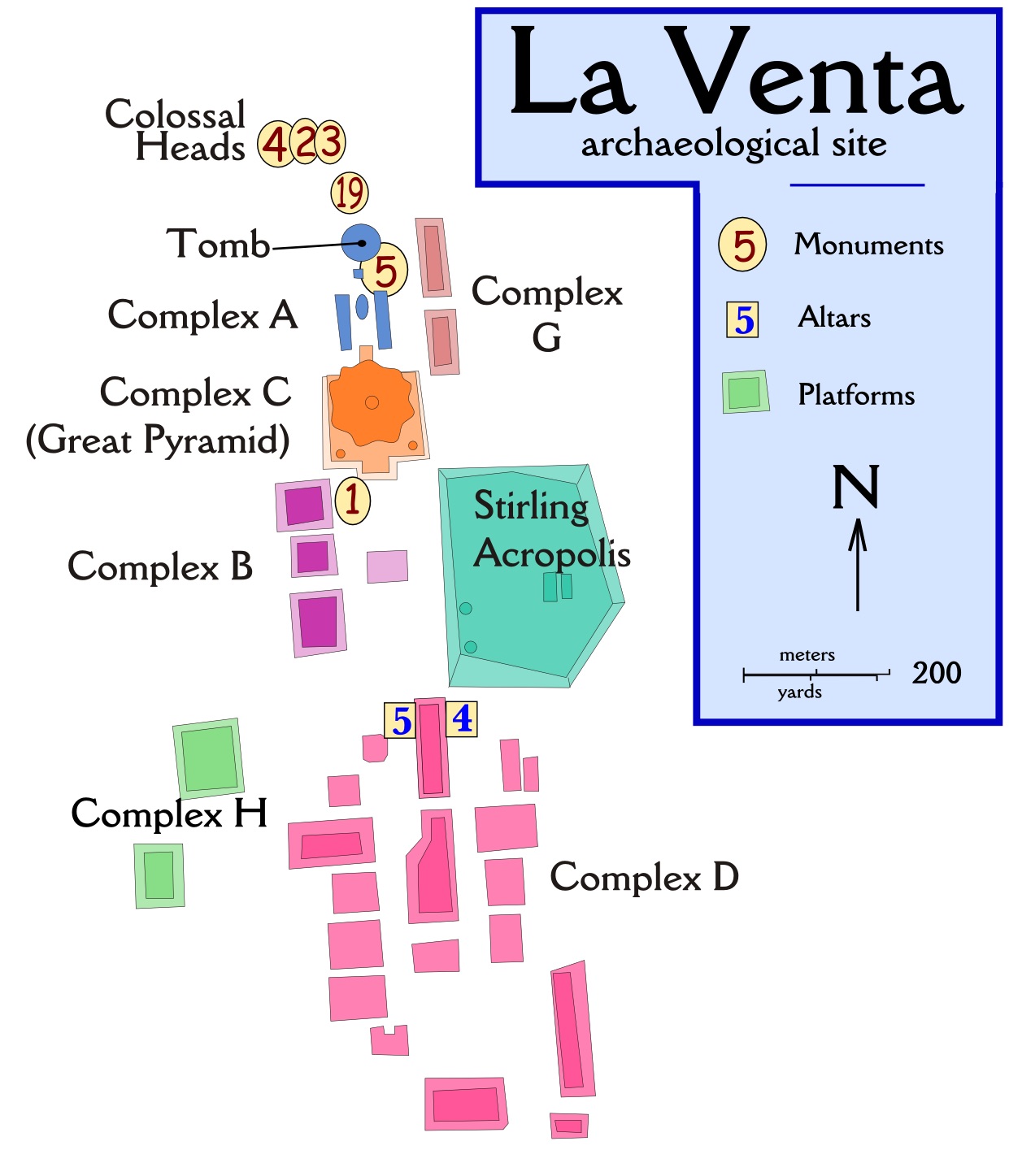
La Venta was built around 1200 BCE on a high ridge above the Palma River less than ten miles from the Gulf of Mexico. By 900 BCE, it had become the dominant Olmec city in the region. At its height, La Venta covered almost five hundred acres and may have supported as many as eighteen thousand people. Its central monuments included several large earthen mounds, plazas, a possible sports arena, several tombs, and numerous stone heads and other sculptures. The complexity of this urban complex reflects a major development in Mesoamerican civilizational and architectural design. It was likely built as a sacred site, with its temples and other complexes organized on a north–south axis believed to enhance the rulers’ authority by connecting them to supernatural environments. This style of urban design was later adopted by other Mesoamerican civilizations like the Maya.
Olmec art depicts numerous deities, such as a dragon god, a bird god, a fish god, and many fertility deities like a maize god and water gods. The Olmec also clearly recognized many types of supernatural mixed beings, like a feathered serpent and the were-jaguar, a cross between a jaguar and a human. These artistic images imply that the Olmec had a sophisticated pantheon of gods who controlled the universe and expected certain rituals be performed, perhaps by Olmec leaders themselves, who may have functioned as shamans empowered to communicate with the spirit world. The rituals were performed in the temples and plazas of the sacred cities like La Venta and San Lorenzo, as well as in sacred natural sites like caves and mountaintops.
Other rituals were connected to a type of ball game played in a special court with balls made from the abundant natural rubber of the region. Sports contests often existed to bring communities together, to allow men to show prowess and strength in times of peace, and to entertain. It is also likely that in times of heightened spiritual need, such contests could take on greater meaning and might have been choreographed to play out supernatural narratives and perhaps connect people to the gods. Like some later civilizations, the Olmec also saw bloodletting as a link to the spirit world. Blood sports may have been used to create pathways to understanding the will of their gods.
The Olmec were clearly in contact with other groups around southern Mexico and Central America. There is evidence of a robust trade in pottery and valued materials like obsidian, magnetite, and shells, likely carried out by merchants traveling across the larger region. Over time, this trade exposed other Mesoamerican cultures to Olmec ideas about religion, art, architecture, and governance. Some scholars thus conclude that Olmec civilization was a “mother culture” for later large and sophisticated Mesoamerican states. Cultural similarities exist among these, such as ritual ball games, deities, and calendar systems. Olmec-style artifacts have also been found at sites as far away as what are now western Mexico and El Salvador. Like much related to the Olmec, however, the extent of their influence is a question we may never answer with certainty. By the time this civilization disappeared around 400 BCE, a number of other Mesoamerican cultures were emerging.
Further Reading
The ritual ball game of the Olmec became a cultural feature of Mesoamerica over the centuries, and various forms of it were played by the Maya, the Aztec, and many others. Read more about the history of the Mesoamerican ball game and see pictures of related artifacts from different Mesoamerican cultures at the Metropolitan Museum of Art website.
Adapted from Ann Kordas, Ryan J. Lynch, Brooke Nelson and Julie Tatlock, World History, Vol. 1 to 1500. Houston: OpenStax, 2030 (https://openstax.org/books/world)
Dr. Lauren Kilroy-Ewbank and Dr. Steven Zucker, “Olmec mask (offering 20 from the Templo Mayor),” in Smarthistory, August 10, 2015, accessed July 31, 2024, https://smarthistory.org/olmec-mask/.
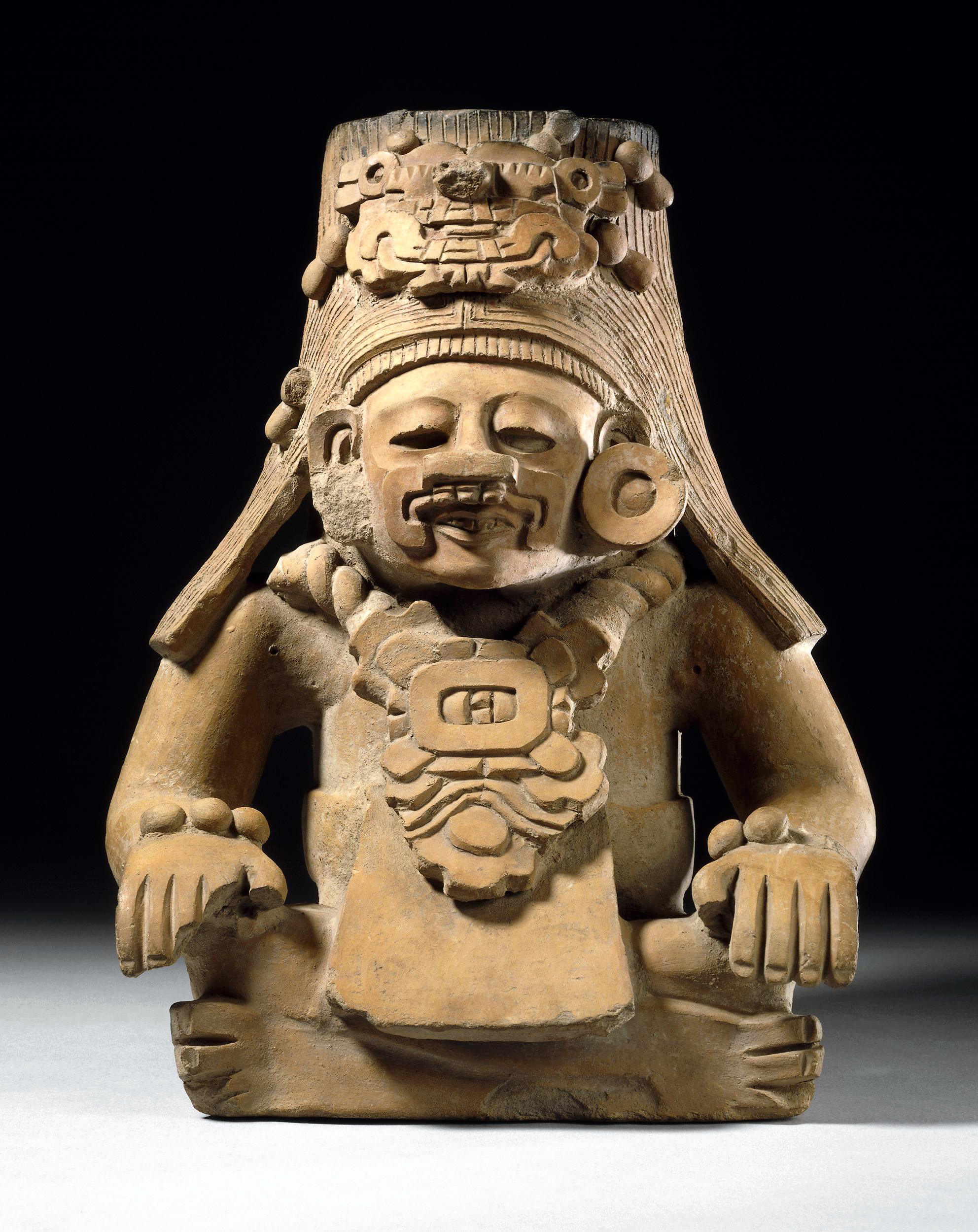
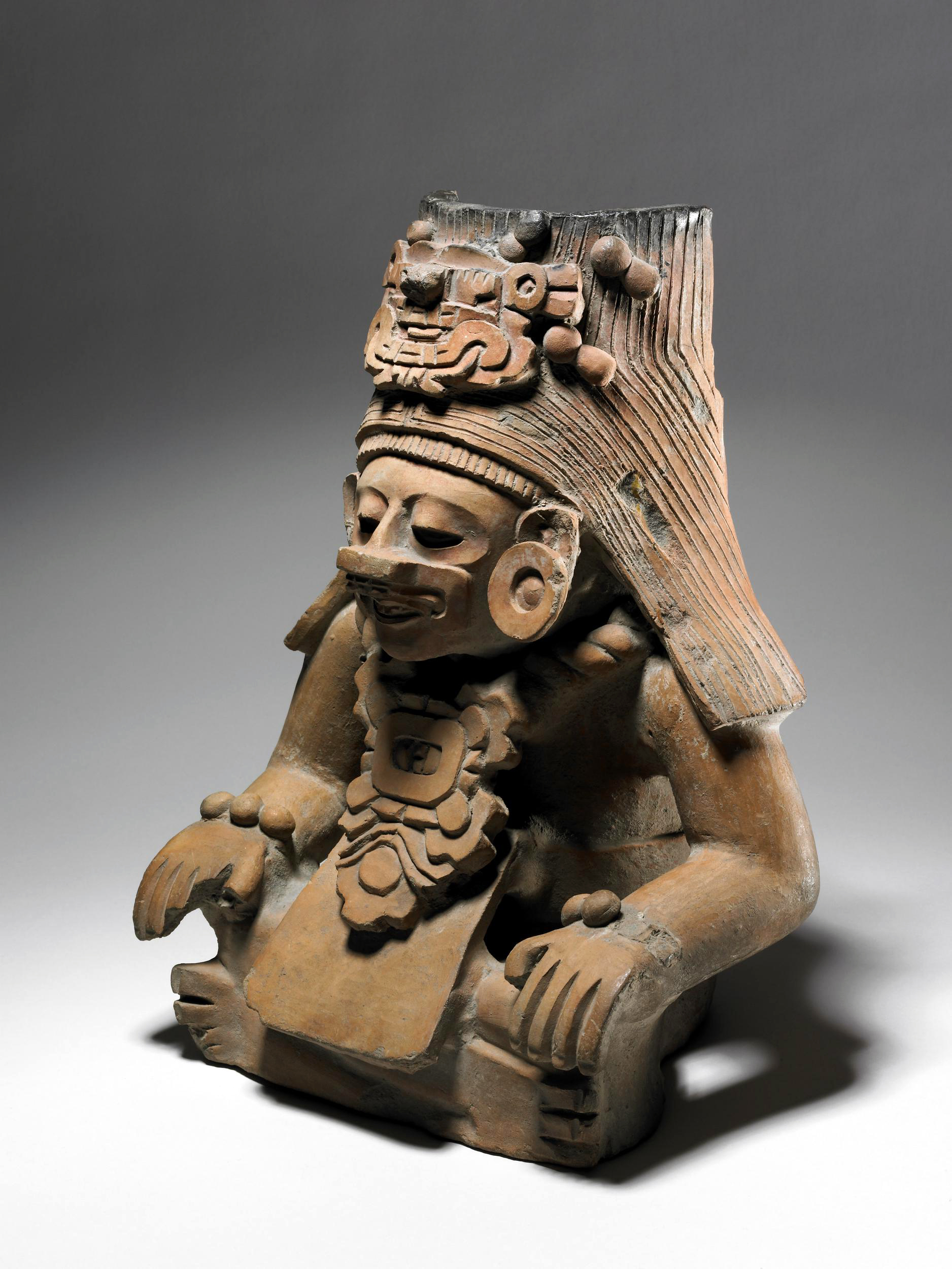
Offering vessels like this one have been found in the tombs of high-ranking Zapotec lords and noblewomen in the Oaxaca Valley in Mexico.
Zapotec nobles were buried in tombs set around the central plaza of their capital at Monte Albán, which was founded in the 6th century B.C.E. and flourished between the 3rd and 7th centuries C.E.. This imposing site was located on the top of a hill with views of the Oaxaca Valley and surrounding mountains. The supporting population, which at its height numbered around 25,000, lived on the terraced slopes in the valley below.
Royal ancestor worship was the focus of Zapotec belief and ceremonial practice and the powerful figures depicted on offering vessels—or funerary urns as they are also known—are thought to represent these ancestors rather than deities. The importance of ancestry lies in the Zapotec use of genealogy and ancestral lines to pass on power and wealth.
Figures like this have been found inside tombs, positioned alongside bodies, as well as in niches in the walls. They’ve also been found buried in the floors of ceremonial centers, seemingly as offerings.
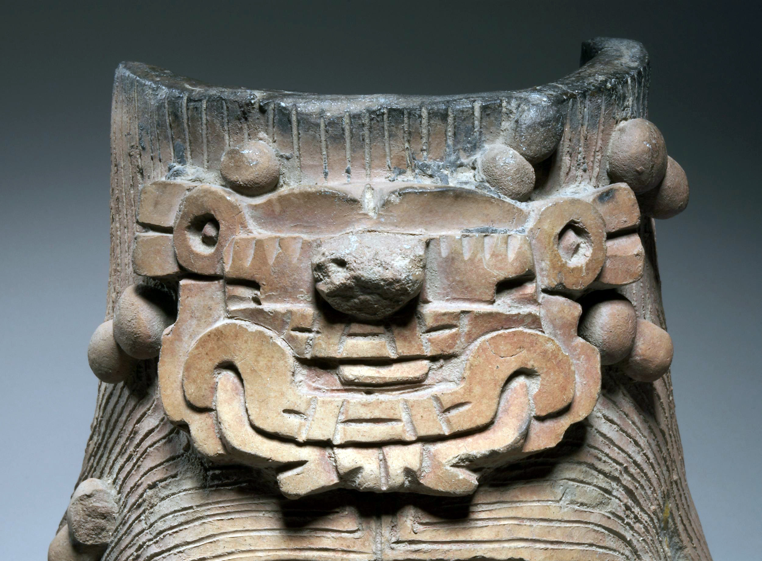
The figure on this example wears a mask and headdress representing the depicted ancestors’ potent supernatural force. The chest ornament features a glyph or sculpted symbol of a day in the 260-day Zapotec ritual calendar.
The exact use and purpose of these vessels is unknown. The container, or urn, itself—usually a cylindrical vessel hidden behind the sculpted figure—may simply have been used to hold perishable offerings, as remains have been found inside.
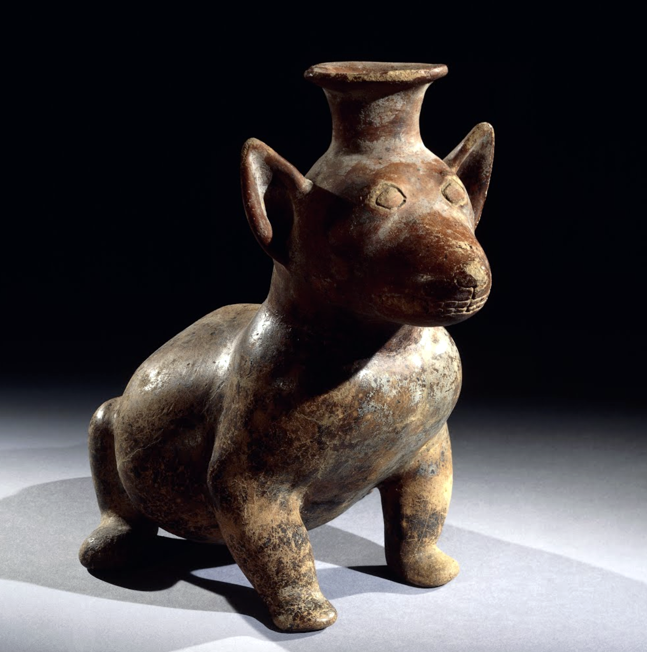
This hollow figure represents a dog, the most commonly portrayed animal in the art of Colima. Dogs were believed to assist the dead in their journey to the Underworld. During the sixteenth century, the dog was also a central figure in the myths of creation, according to sources which themselves referred to Colima’s ancient inhabitants.
The type of dog depicted here is a hairless breed, which was eaten at feasts. The same breed is found in Ecuador and on the coast of Peru and may have been introduced from there to West Mexico. Dogs are not the only animals portrayed in the ceramics of Colima: fauna (ducks, fish, crabs, parrots and serpents, for example), and flora (such as squashes, fruits and cacti) are all realistically represented. Human representations include hunchbacks and dwarfs, musicians playing a variety of instruments, and males holding bowls. Women are rarely depicted.
The ceramics of Colima represent a wider diversity of themes and shapes than those of Jalisco and Nayarit, but there is less variety in style. They generally exhibit a great naturalism. Best known are the hollow figures with a glossy slip. Their color varies from deep red to light orange, although some of them are blackened as a result of the firing process.
Source: The British Museum, “Pottery dog, Colima culture,” in Smarthistory, March 12, 2021, accessed July 31, 2024, https://smarthistory.org/dog-colima/.
Teotihuacan
by Dr. Maya Jiménez
Teotihuacan, Mexico, main structures c. 50–250 C.E. Speakers: Dr. Lauren Kilroy-Ewbank and Dr. Beth Harris URL: https://youtu.be/taCxra5ezKg
Metropolis
An impressive city of 125,000–200,000 inhabitants, by the 6th century, Teotihuacan was the first large metropolis in the Americas. Teotihuacan, as the city is called, is a Nahuatl name that means “the place where the gods were created” and was given by the Mexica (sometimes called Aztec) centuries after it was abandoned in the 7th century. The Aztecs attributed names and significance to its buildings but had no contact with this earlier culture. Very little is known of the people who built Teotihuacan, and as a result, much of our knowledge of the site, its art, and Teotihuacan culture is derived from Aztec sources. Largely created before 250 C.E., Teotihuacan is a testament to the ambition of its people, who built the first American city on a grid plan.
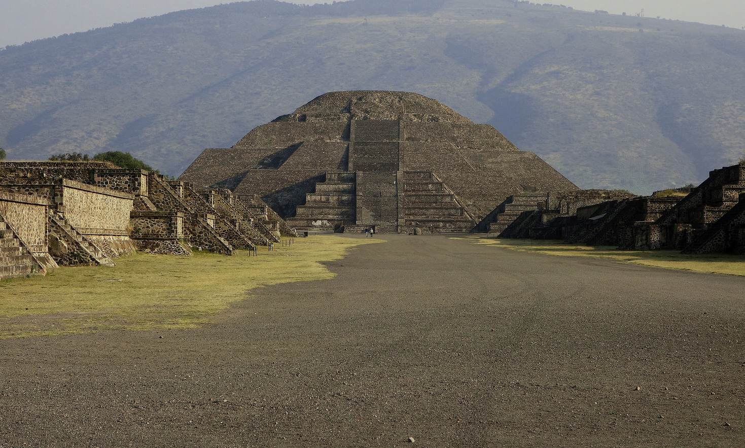
Pyramid of the Moon seen from the Avenue of the Dead with Cerro Gordo in the distance, Teotihuacan, Mexico (photo: Steven Zucker, CC BY-NC-SA 2.0)
Due to an absence of (or as of yet undiscovered) royal palaces and graves, the lack of evidence for a cult of personality, and the as-of-yet undeciphered hieroglyphs, the governing system of Teotihuacan remains largely elusive to scholars. Nevertheless, the dramatic monumental architecture and dense urban fabric reveal a complex environment carefully planned to support a large population but also structured by the surrounding natural environment and in relation to specific constellations and planetary events. In keeping with the stratified nature of other Mesoamerican societies, Teotihuacan also benefitted from rulers, or a ruling elite, who commissioned massive architectural landmarks such as the Pyramids of the Sun and Moon, and who spread Teotihuacan’s sphere of influence throughout Mesoamerica—even into the Maya region as far away as Guatemala.
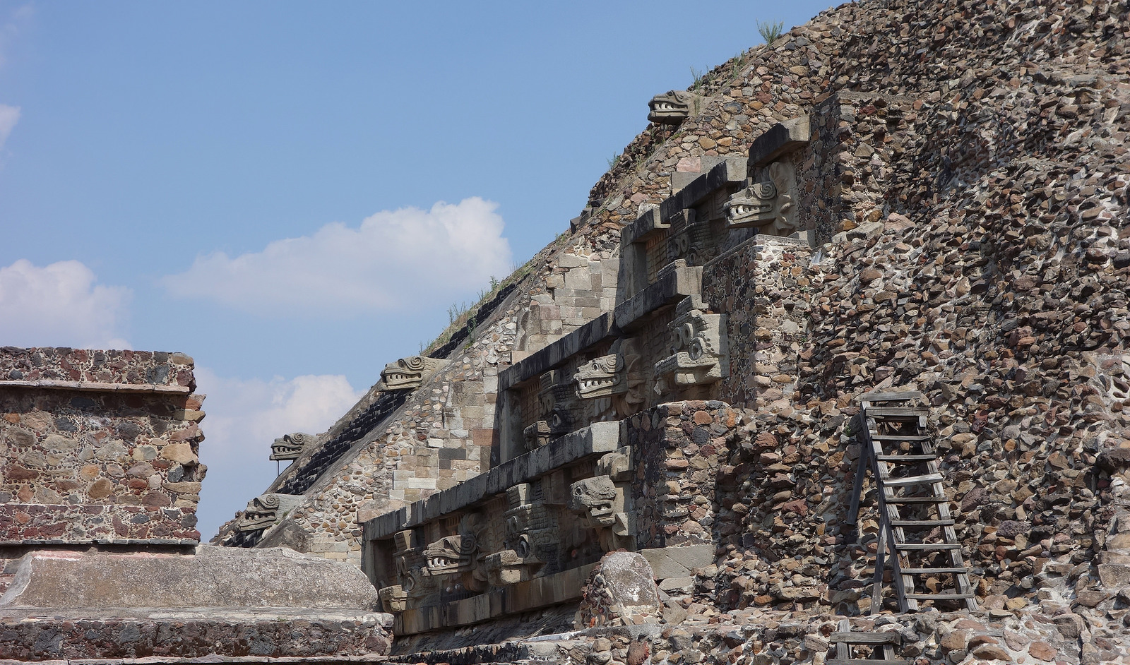
Pyramid the Temple of Quetzalcoatl (feathered serpent), Teotihuacan, Mexico (photo: Steven Zucker, CC BY-NC-SA 2.0)
Plan and Pyramids
The city of Teotihuacan is aligned, like other Mesoamerican cities such as La Venta, on a north-south axis. This alignment is made explicit by the central artery, known as the Avenue of the Dead, which extends more than 1.5 miles across the city. Entering the city from the south, the Avenue of the Dead leads visitors to the city’s three main architectural monuments, the Ciudadela, a sunken plaza at the southernmost tip that contains temples, including the Pyramid of the Feathered Serpent, the Pyramid of the Sun further down the avenue, and the Pyramid of the Moon located at the northernmost point. In the distance and behind the Pyramid of the Moon, visitors can also catch a glimpse of the impressive Cerro Gordo, an extinct volcano that frames the pyramid and demonstrates the harmonious relationship between architecture and natural topography. Running perpendicular to the Avenue of the Dead, another street follows the San Juan River. These axes help to define the grid of intersecting horizontal and vertical corridors that structure and organize the city plan. The urban grid helped to establish order for religious, domestic, and commercial complexes and a structural coherence that supported the management of the city and its population. Thousands of apartment complexes also reflect the ordered planning of the site.
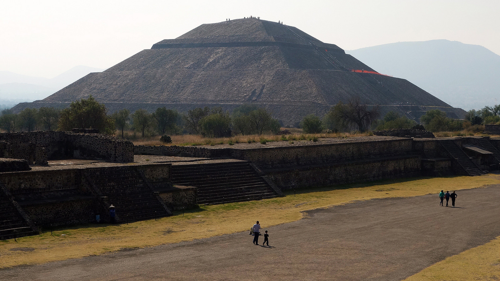
Pyramid of the Sun and the Avenue of the Dead, Teotihuacan, Mexico (photo: Steven Zucker, CC BY-NC-SA 2.0)
The Pyramid of the Sun, which reaches a height of over 200 feet, was the tallest structure in the Americas at the time. Built over a cave, it is unclear who or what the pyramid was built to commemorate, although art historians have suggested that creation mythology may be at issue, since Aztec and Maya sources refer to caves as places of origin and fertility. The pyramid was meant to be viewed and approached from the East. Visitors can still climb the pyramid’s steep staircase, which originates near the Avenue of the Dead and rises over five levels to what is now a bare flattened top. Keep in mind that this pyramid was heavily reconstructed in the modern era, so its original shape may have appeared somewhat differently than it does today.
Pyramid of Quetzalcoatl (feathered serpent), Teotihuacan, Mexico (photo: Steven Zucker, CC BY-NC-SA 2.0)
The Pyramid of the Feathered Serpent occupies a prominent place in the Ciudadela, a large open space that offers a respite from the massive presence of the Pyramid of the Sun and Pyramid of the Moon. Like so much else at Teotihuacan, the Pyramid of the Feathered Serpent was built in the talud-tablero style. The temple stands out for its sculptural ornamentation depicting the feathered serpent, known by its Aztec name Quetzalcoatl. The feathered serpent is associated with water imagery and is depicted numerous times on the exterior of the temple as an undulating snake navigating among seashells. Two faces project outwards, one of which depicts the feathered serpent. The identification of the other head is more challenging. One interpretation is that it represents an early version of the Aztec god Tlaloc (known for his goggled eyes) and is associated with rain and warfare. However, some scholars identify the head as an early precedent of Xiuhcoatl, or Fire Serpent, who was associated with warfare, fire, and time (or the calendar). Most scholars agree that the temple was associated with warfare and human sacrifice, as confirmed by numerous skeletal remains (presumably of warriors) that were discovered by archeologists in the 1980s. Speculation has also arisen about whether the Pyramid of the Feathered Serpent may have contained the body of a ruler.
Agustín Villagra, reconstruction of mural from Tepantitla in Teotihuacan in the National Museum of Anthropology in Mexico City (photo: Steven Zucker, CC BY-NC-SA 2.0)
Paintings
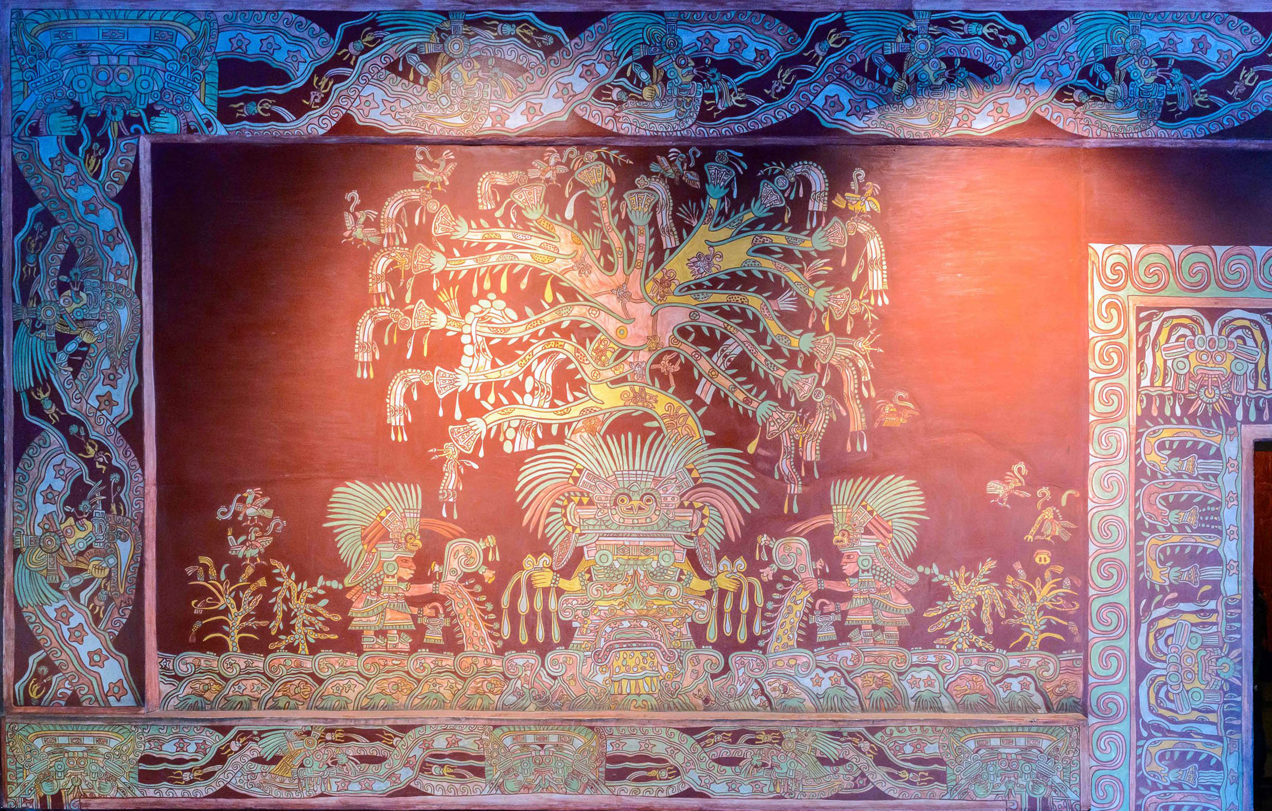
Teotihuacan was a heavily painted site, with murals found throughout the city. For example, on the walls of the apartment complex in the Tepantitla district, we find an elaborate mural showing a figure often identified as the Great Goddess and, more recently, as a mountain-tree. The female figure stands frontally while a blossoming tree with butterflies and spiders emerges from her head (potentially a reference to the heavenly realm), while her feet remain attached to the underworld. The inverted u-shape found below the mountain-tree may function as a symbolic womb, similar to the cave found at the Pyramid of the Sun.
The identity of the two individuals to her side, possibly priests, have sparked interest. Considering the cosmopolitan nature of the city, it had been thought that Teotihuacan’s figurative art was not portraiture, but rather generic representations that sought to unify a diverse population. Recently, however, some painted signs have been recognized as representing the names of individuals, leading to a re-examination of whether Teotihuacan artists portrayed specific individuals and reminding us that there is still much to learn about this complex and ancient city.
Archeologists have dated the city’s collapse to the seventh century, when many of Teotihuacan’s buildings were destroyed.
Pyramid of the Moon and Pyramid of the Sun, Teotihuacan
by Dr. Lauren Kilroy-Ewbank and Dr. Beth Harris
The Pyramid of the Moon and Pyramid of the Sun are massive architectural constructions that tell us a lot about Teotihuacan culture.
The Pyramid of the Moon and the Pyramid of the Sun, Teotihuacan, c. 1st century C.E., Mexico. Speakers: Dr. Lauren Kilroy-Ewbank and Dr. Beth Harris URL: https://youtu.be/Zdsi0qKVJO8
The 5000-year-old 626-hectare archaeological site of The Sacred City of Caral-Supe is situated on a dry desert terrace overlooking the green valley of the Supe River. It dates back to the Late Archaic Period of the Central Andes and is the oldest centre of civilization in the Americas. Exceptionally well-preserved, the site is impressive in terms of its design and the complexity of its architectural, especially its monumental stone and earthen platform mounts and sunken circular courts. One of 18 urban settlements situated in the same area, Caral features complex and monumental architecture, including six large pyramidal structures. A quipu (the knot system used in Andean civilizations to record information) found on the site testifies to the development and complexity of Caral society. The city’s plan and some of its components, including pyramidal structures and residence of the elite, show clear evidence of ceremonial functions, signifying a powerful religious ideology.
Nasca Geoglyphs
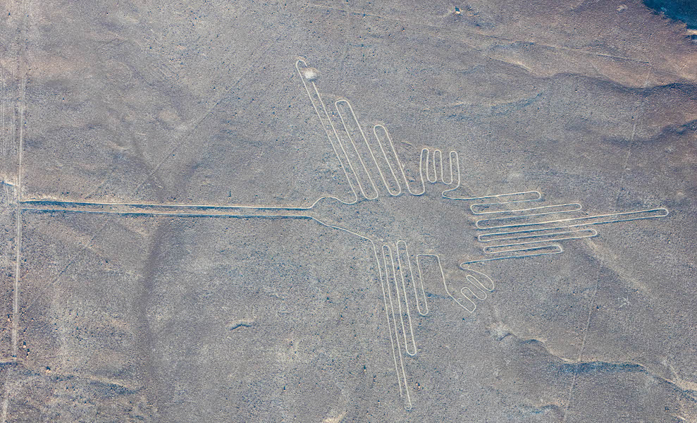
Hummingbird, Nasca Geoglyph, over 300 feet in length, formed approximately 2000 years ago (photo: Diego Delso , CC BY-SA 4.0
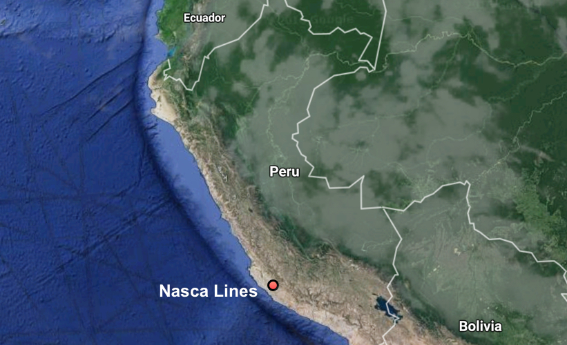
Locaed in the desert on the South Coast of Peru, the Nasca Geoglyphs are among the world’s largest drawings. Also referred to as the Nasca Lines, they are more accurately called geoglyphs, which are designs formed on the earth. Geoglyphs are usually constructed from strong natural material, such as stone, and are notably large in scale.
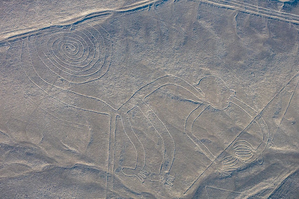
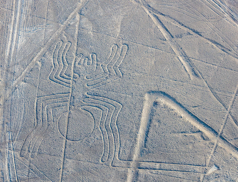
Imagine encountering such a drawing. The hummingbird measures over 300 feet in length, and is one of the most famous Nasca Geoglyphs. Among the other celebrated geoglyphs of mammals, birds and insects are a monkey, killer whale, spider, and condor. Various plants, geometric shapes (spirals, zigzag lines and trapezoids), abstract patterns, and intersecting lines fill the desert plain, known as the Pampa, an area covering approximately 200 square miles near the foothills of the Andes. The zoomorphic geoglyphs are the oldest and most esteemed. Each appears to have been made with a single continuous line.
Today it is believed that the geoglyphs were created by the Nasca people, whose culture flourished in Peru sometime between 1-700 C.E. They inhabited the river valleys of the Rio Grande de Nasca and the Ica Valley in the southern region of Peru, where they were able to farm, despite the desert environment—one of the driest regions in the world. The high Andes Mountains to the east prevent moisture from the Amazon from reaching the coast, so there is very little rainfall; water that does arrive, comes from mountain runoff.
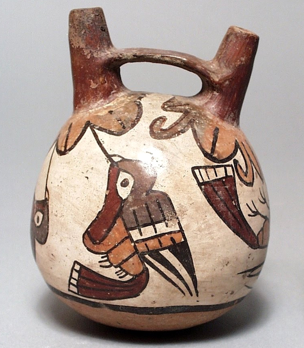
The Nasca people are also famous for their polychrome pottery, which shares some of the same subjects that appear in the Nasca Geoglyphs. Remains of Nasca pottery left as offerings have been found in and near the geoglyphs, cementing the connection between the geoglyphs and the Nasca people. Because the quality of the ceramics produced in Nasca is very high, archaeologists deduce that specialists shaped and painted the pottery vessels. This suggests a society that, at its height, had a degree of wealth and a division of labor. However, the Nasca people had no writing. In cultures without writing, images often assume an increased level of importance. This may help explain why the Nasca came together to create vast images on the desert floor.
Double-Spout and Bridge Vessel, c. 100-700 C.E., Nasca, Peru, polychrome ceramic, 12.07 x 10.16 cm (Los Angeles County Museum of Art)
How were they made?
Since the Nasca geoglyphs are so large, it seems clear they were constructed by organized groups of people and that no single artist made them. The construction of the geoglyphs are thought to represent organized labor where a small group of individuals directed the design and creation of the lines, a process that may have strengthened the social unity of the community. Despite the impressive scale of the geoglyphs, these remarkable works did not require complex technology. Most geoglyphs were formed by removing weathered stones from the desert floor, stones that had developed a dark patina known as “desert varnish” on their surface. Once removed, the lighter stones below became visible, forming the famous Nasca Lines. The extracted darker stones were placed at the edges of the lines, forming a border that accented the lighter lines within. Straight lines could be created by extending cords, one on each side of the line, between two wooden stakes (some of which have been recovered) that guided workers and allowed for the creation of sight lines.
For larger geometric shapes, such as trapezoids, borders were marked and then all the stones on the interior were removed and placed along edges or heaped in piles at the edges of the geoglyph. Broken pottery has been found mixed with the piles of stones. Spirals and animal shapes were made in a similar manner. Spirals, for example, would be formed by releasing slack in a cord as workers moved around in a circular path, moving further and further from the center where the spiraling line begins. For animal forms, such as monkeys, whales, or hummingbirds, portions of the figures might be made in the same manner as the spiral in the monkey’s tail, or the image might be based on a gridded drawing or textile model that was enlarged on the desert floor where lines were staked out to create the figure.
When were they made?
The oldest of the Nasca Geoglyphs is more than 2000 years of old, but, as a group, the Nasca geoglyphs were created over several centuries, with some later lines or shapes intersecting or overlapping with previously created lines. This is just one of the unusual features of these geoglyphs. Even more curious, the drawings are best observed from the air, which is why they did not become widely known until the 1920s after the development of flight. Although it is possible to observe some of the lines from the adjacent Andean foothills or the modern mirador (viewing platform), the best way to see the lines today remains a flight in a small plane over the Pampa (lowlands). These amazing images are so large that they cannot be truly appreciated from the ground. This, of course, raises the question: for whom were the lines made? And, what was their purpose?
Monkey with Spiral Tail, Nasca Geoglyph, approximately 2000 years old (photo: Diego Delso , CC BY-SA 4.0
What was their purpose and meaning?
Archaeologists are not certain of the purpose of the lines, or even of the audience for whom the lines were intended since they can only be seen clearly from the air (This is now particularly true of the older animal designs). Were they made to be seen by deities looking down from the heavens or from distant mountain tops? Perhaps the numerous theories that have been proposed will eventually be clarified as our understanding of the cultures of ancient Peru increases.
Celestial alignments?
Shortly after the geoglyphs were first investigated, researchers sought an astronomical interpretation, suggesting that the geoglyphs might be aligned with the heavens, and perhaps represented constellations or marked the solstices or planetary trajectories. While some geoglyphs seem connected to celestial events, such as marking the summer solstice (in December) when mountain waters flow to the coast, it is difficult to find celestial alignments for most of the geoglyphs. As far as we know, Andean peoples did not form pictures by connecting the stars in the night sky as we do; rather they looked at the black spaces between stars and saw shapes that they converted into their own reverse “constellations.” It is important to note that these constellations do not seem to match the Nasca geoglyphs.
Deities or ceremonial walkways?
Many other reasonable theories have been proposed. Some scholars have suggested that the geoglyphs represent Nasca deities, or formed a calendar for farming, or represented ceremonial walkways. Because some of the lines do seem to direct people to Cahuachi, a Nasca religious center and pilgrimage destination, it seems possible that ancient Nasca people walked the lines. It is also possible that Nasca people ritually danced on the lines, perhaps in connection with shamanism and the use of hallucinogens. The geoglyphs, particularly the early animals which are clearly spaced apart from each other, may also have strengthened group identity and reinforced social interaction patterns as individual groups of people may each have tended or “owned” one of the geoglyphs,
Spider, Nasca Geoglyph, over 300 feet in length, formed approximately 2000 years ago (photo: Diego Delso , CC BY-SA 4.0)
A discredited theory proposed that the geoglyphs are the result of alien contact. While this is sensationalist and helped to secure the popular fame of the Nasca geoglyphs, there is no evidence to support this assertion. Archaeologists and scientists have rejected this proposal and it is important to recognize the implication of this theory is that the Nasca people needed the influence of aliens peoples to create their geoglyphs. We know that the technology to manufacture the geoglyphs was available to the Nasca people and that they had a social system that was fully capable of organizing and producing large geoglyphs. We also know that the designs are consistent with other art forms native to Nasca culture.
Farming, fertility, and water?
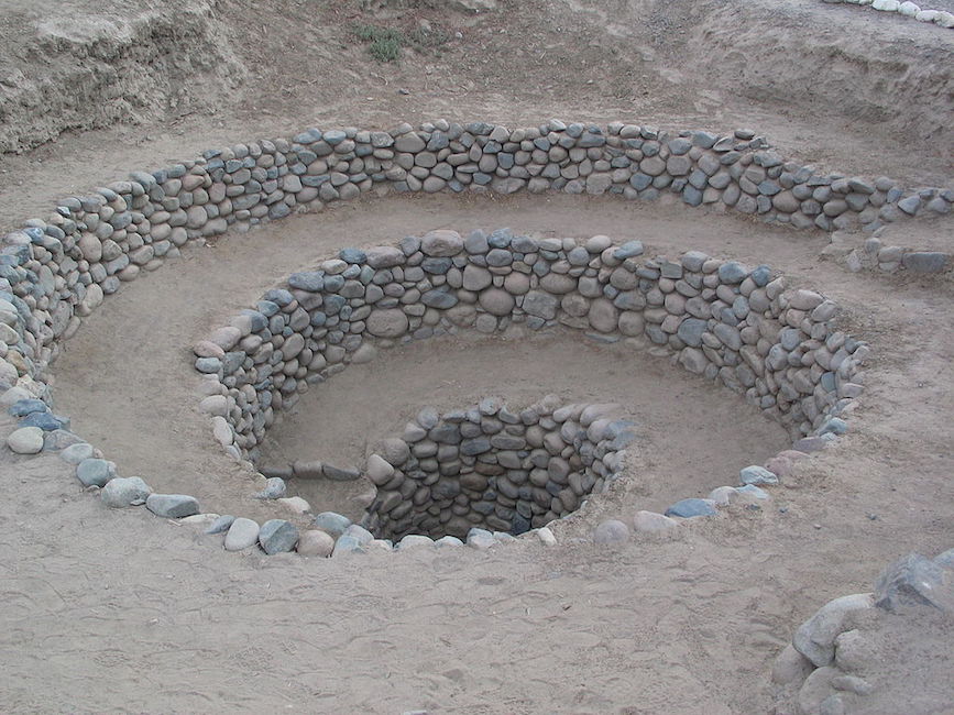
Among the most promising recent theories, archaeologists have begun to secure a link between the geoglyphs and farming, which sustained the Nasca people. Some geoglyphs may deal with fertility for crops; others may be associated with the water needed to raise the crops. In a desert, water is the most important commodity. In Andean mythology the mountains are revered as the home of the gods. It has been suggested that the lines were intended to be visible to the gods in the mountains. Some lines also seem to point in the direction of the mountains — the origin of fresh water for the desert South Coast of Peru. Snow pack melts high in the mountains and becomes runoff and a vital source of water for the coast. In fact, ancient underground water channels are sometimes marked on the surface by Nasca geoglyphs, particularly at the points of intersection. These have been dubbed “ray centers,” spots where lines converge. Offerings have been found at these points, including conch shells. The spirals on the desert floor, in the monkey’s tail, and as independent abstract designs, may refer to the spirals found in conch shells and thus may reference water. This same shape appears in Nasca puquios —gradually descending tunnels that tap ancient subterranean aquifers and water channels. Puquios have been described as wells, and formed part of this ancient irrigation system. Puquios, found in Nasca (and elsewhere in Peru), allowed people to reach water in times of drought. Geoglyphs other than spirals may also be directly associated with water.
Puquio, South Coast of Peru
Preservation
Because the Nasca Geoglyphs were made directly on the earth by rearranging stones on the desert floor, these giant images are actually quite vulnerable to damage. In time the lighter-colored stones exposed by the Nasca people may attain their own patina, making them less visible, but the designs face greater threats from vehicle and pedestrian traffic. Crossing the lines can damage their borders and make the images less distinct. Because of this, the Peruvian government has created a mirador (viewing platform) along the Pan American Highway where visitors can climb to view a few drawings without damaging the lines.
In the end, it is likely that the Nasca Geoglyphs served more than one purpose, and these purposes may have changed over the centuries, especially given that new lines often “erased” older ones by “drawing” over them. It does appear that many geoglyphs made reference to water and agricultural fertility, and were used to promote the welfare of the Nasca people. The geoglyphs were also a place where people gathered, perhaps for pilgrimage, perhaps to walk or dance on the lines in a ritual pattern. As a gathering place, the Nasca geoglyphs may additionally have turned the Pampa into a map of social divisions, where different families or clans tended different geoglyphs. Although we do not know exact details, we can surmise that the geoglyphs represent a community investment meant to serve this ancient people.
Backstory
In January, 2018, a semi truck traveling through Peru on the Pan-American highway veered off the road and plowed through the desert. The deep ruts that it made damaged several of the Nasca lines. Though the area is clearly marked as a protected zone, according to the archeologist Johnny Isla , co-director of the Nasca-Palpa Project, cases like this “occur daily.” The driver, who authorities suspect may have been trying to avoid a toll, was charged with an “attack against cultural heritage.”
Human interventions like this constitute the main threat to the Nasca-Palpa area, whose geoglyphs extend across almost 300 square miles. In 2014, Greenpeace activists damaged the desert floor around the famous hummingbird geoglyph as they lay out a large protest sign meant to be seen from the air. Their action was a protest against climate change during the United Nations summit in Lima, and was not intended to damage the site; the organization has since apologized. However, the marks made by the activists’ footprints have been deemed possibly “irreparable” by Luis Jaime Castillo Butters, a professor of archeology and Peru’s Vice Minister for Cultural Heritage. “A bad step, a heavy step … marks the ground forever,” he said . “There is no known technique to restore it the way it was.”
The construction of the Pan-American highway has also increased the risks to the area, not only because of vehicles that can potentially veer off the road, but also because rains and mud can wash off of the surface and damage the lines .
Nasca-Palpa was designated as a UNESCO World Heritage Site in 1994. In contrast to many other at-risk heritage sites around the world, UNESCO states that
Even though there have been some impacts caused by natural and human factors, these have been minimal and the geoglyphs maintain their authenticity and express their high symbolic and historic value even today.
The most pressing need, now being discussed by Isla and others , is for better, 24-hour monitoring of the area — possibly using drone technology — so that human incursions on the site can be quickly addressed and avoided.
Born around 1210, Sundiata Keita (also known as Sunjaata or Sunjata) is credited by oral tradition with founding the powerful and wealthy Mali Empire in West Africa. Sundiata was the “lion prince” of the Malinke people of West Africa and the various oral traditions, collectively known in English as the Epic of Sundiata, describe him variously as a warrior, able administrator, magician, and hunter––themselves considered to possess supernatural powers “through their communication with the spirits of the bush.”1
Sundiata’s legend is passed down through the efforts of griots, or professional storytellers who in different periods of Malian history also served as important political advisors and official historians. While a legendary figure, Sundiata’s existence is corroborated by the famous traveler and writer Ibn Battuta in the following century.
According to the tradition transmitted by the Epic of Sundiata, Sundiata selected a capital city at Niani and the leaders of clans also decided that Mali’s rulers would be drawn from Sundiata’s new dynastic line. The stability of this new empire meant that it could enrich itself by taking advantage of local gold deposits and trans-Saharan trade networks.
By drawing a comparison from the same region just a century and a half earlier, we can get a better sense of how religious syncretism––the practice of different traditions simultaneously––could work in medieval West Africa. The ruler of Malal, a predecessor state to what would later become known as Mali, Wâr-Djâbî ibn Râbîs (d. c. 1040), was among the first rulers in the region to convert to Islam and received religions instruction from one Alî, a member of his court. Rulers of Ghana would become Muslim in the middle of the next century: through missionary work and the efforts of the ulamas (or Muslim clergy) “these conversions affected the top of society: the king covnerted first, then his entourage, while perhaps waiting for the rest of his subjects.”5 According to the later Arabic sources on this incident, apparently at least some of the king’s subjects begged him, “do not change our religion” even though the elite had decided to convert. In the analysis of François-Xavier Fauvelle,
“This certainly allowed the converted monarch, even if he himself rejected the idols, to listen to his subjects when they said, ‘Do not change our religion’––to remain, in their eyes, the protector of the traditional cults. There was no contradiction here, either for him or for hte population that remained ‘pagan’: in Malal’s case, it was precisely the efficacious intercession of the God of the Muslims that allowed the king to preserve his traditional role as guarantor of the rain and the harvests. As the sovereign’s legitimacy was everyone’s concern, . . . it was particular important that the monarch was a good Muslim, even if Islam was not the religion of his subjects.”6
In other words, the king’s Muslim faith was an admirable addition to the region’s religious traditions as long as the harvests remained adequate. We probably have good reason to see this as an instructive parallel to the conversion of Sundiata, who continued to be a protector of Mali’s indigenous faith traditions.
By 1255 Sundiata was dead but his legacy was cemented. Future kinds (or “Mansas”) would draw from his legacy to bolster their own legitimacy, as is especially the case with the fabulously wealthy and pious Mansa Musa, whose hajj of 1324 took him through the greatest cities of the Islamic world and put Mali near the center of that world’s map.
Themes and Contents of the Text
African historian Michael Gomez details three central themes in the Epic of Sundiata7
The Epic, while a legend similar to the Iliad or Odyssey, contains discussions of some “historical developments corroborated by independent sources yielding high probability.” These include an early connection to Islam and a general outline of the career of Sundiata.
The Epic concerns itself mainly with “dynastic rivalry and troubled familial relations, problematic aspects of Sunjata’s character, and the acceleration of gender-dominated political office.” This includes the treatment of Sogolon, Sundiata’s mother, as well as the trope of rejection/exile.
The Epic focuses on “Mande values and perspectives featuring extensive, everyday interactions between the physical and noumenal, social stratification, interclan relations, gender protocols, parenting, and the etiquette of power.” These include Sundiata’s relationship with his own disability, Sogolon’s struggles at the court of Nare Maghan, the Mande king, as well as descriptions of the wars Sundiata wages against (what he sees as, and what the audience of the Epic should see as) the illegitimate rule of his relatives.
The Epic of Sundiata is meant to be performed with musical accompaniment and while “there was necessarily drift over time in content and performance . . . the need to faithfully reproduce the songs remained a priority, placing constraints upon intentional emendation while reducing susceptibility to improvisation.” In other words, “the songs police the process.” [F = Gomez, Dominion, 64] While the earliest written versions of the Epic are from the seventeenth century, the form and tradition of this oral epic practically ensure that the main messages, values, and plot points would remain in place across the centuries.


